<?xml version="1.0" encoding="ISO-8859-1"?>
<feed version="0.3" xmlns="http://purl.org/atom/ns#" xml:lang="en-US">
	<title>News &amp; Views</title>
	<link rel="alternate" type="text/html" href="http://mylandmatters.com/News/Items/index.php" />
	<modified>2026-09-15T16:43:55Z</modified>
	<author>
		<name>Leigh</name>
		<email>leigh@mylandmatters.org</email>
	</author>
	<copyright>Copyright 2026, Leigh</copyright>
	<generator url="http://www.sourceforge.net/projects/sphpblog" version="0.4.4i">SPHPBLOG</generator>
	<entry>
		<title>50 Years of Wild &amp; Scenic Rivers</title>
		<link rel="alternate" type="text/html" href="http://mylandmatters.com/News/Items/index.php?entry=entry181003-133725" />
		<content type="text/html" mode="escaped"><![CDATA[The Wild and Scenic Rivers Act was passed 50 years ago this week.  On October 2, 1968 the US Congress passed Public Law 90-542.<br /><br /><i>It is hereby declared to be the policy of the United States that certain selected rivers of the Nation which, with their immediate environments, possess outstandingly remarkable scenic, recreational, geologic, fish and wildlife, historic, cultural, or other similar values, shall be preserved in free-flowing condition, and that they and their immediate environments shall be protected for the benefit and enjoyment of present and future generations.</i><br /><br />Read the complete law as published in the <a href="http://www.mylandmatters.org/Library/Item=8083" target="_blank" >Land Matters Library</a> <br /><br />Land Matters is working on a mapping project that will provide a comprehensive view of the National Wild &amp; Scenic Rivers System. Since 1968, there have been 209 Wild and Scenic River Designations that cover almost 13,000 miles of river. The most recent being in August of 2018 for 20 miles on East Rosebud Creek in Montana.<br /><br />Our Wild &amp; Scenic Rivers Project Map shows all National Wild &amp; Scenic Rivers and their designations (wild, scenic or recreational) and includes eight designated Study Rivers. <a href="http://mylandmatters.org/Maps/NewProjects.html" target="_blank" >WSR Project Map</a> <br /><br />When using the map, SELECT the Information Tool, CLICK on a Wild and Scenic River and the results window returns a link to the Public Law that designated the river. You will also find many of the WSR Management Plans in the Library.<br /><br />Future Additions include mapping of administrative boundaries, historic Wild &amp; Scenic Study Rivers and a full complement of Wild and Scenic River documents in the Library. We will keep you updated as things progress.<br /> <br /><img src="images/fossil_creek.jpg" " width=520" height=257></p>]]></content>
		<id>http://mylandmatters.com/News/Items/index.php?entry=entry181003-133725</id>
		<issued>2018-10-03T00:00:00Z</issued>
		<modified>2018-10-03T00:00:00Z</modified>
	</entry>
	<entry>
		<title>50 Years of Wild &amp; Scenic Rivers</title>
		<link rel="alternate" type="text/html" href="http://mylandmatters.com/News/Items/index.php?entry=entry181003-133725" />
		<content type="text/html" mode="escaped"><![CDATA[The Wild and Scenic Rivers Act was passed 50 years ago this week.  On October 2, 1968 the US Congress passed Public Law 90-542.<br /><br /><i>It is hereby declared to be the policy of the United States that certain selected rivers of the Nation which, with their immediate environments, possess outstandingly remarkable scenic, recreational, geologic, fish and wildlife, historic, cultural, or other similar values, shall be preserved in free-flowing condition, and that they and their immediate environments shall be protected for the benefit and enjoyment of present and future generations.</i><br /><br />Read the complete law as published in the <a href="http://www.mylandmatters.org/Library/Item=8083" target="_blank" >Land Matters Library</a> <br /><br />Land Matters is working on a mapping project that will provide a comprehensive view of the National Wild &amp; Scenic Rivers System. Since 1968, there have been 209 Wild and Scenic River Designations that cover almost 13,000 miles of river. The most recent being in August of 2018 for 20 miles on East Rosebud Creek in Montana.<br /><br />Our Wild &amp; Scenic Rivers Project Map shows all National Wild &amp; Scenic Rivers and their designations (wild, scenic or recreational) and includes eight designated Study Rivers. <a href="http://mylandmatters.org/Maps/NewProjects.html" target="_blank" >WSR Project Map</a> <br /><br />When using the map, SELECT the Information Tool, CLICK on a Wild and Scenic River and the results window returns a link to the Public Law that designated the river. You will also find many of the WSR Management Plans in the Library.<br /><br />Future Additions include mapping of administrative boundaries, historic Wild &amp; Scenic Study Rivers and a full complement of Wild and Scenic River documents in the Library. We will keep you updated as things progress.<br /> <br /><img src="images/fossil_creek.jpg" " width=520" height=257></p>]]></content>
		<id>http://mylandmatters.com/News/Items/index.php?entry=entry181003-133725</id>
		<issued>2018-10-03T00:00:00Z</issued>
		<modified>2018-10-03T00:00:00Z</modified>
	</entry>
	<entry>
		<title>Land Matters Prospecting Research Tools</title>
		<link rel="alternate" type="text/html" href="http://mylandmatters.com/News/Items/index.php?entry=entry171127-175812" />
		<content type="text/html" mode="escaped"><![CDATA[
<table border="0" width=“592">
      <tr valign="top" >
               <td> 
       	 <div style="width:300px; margin-right=10px" align="left" > <p> 
On the Land Matters Website, we provide many tools that can help you locate good places to prospect. <br />The library is full of historic prospecting information and our interactive maps can help you locate old mines, diggings and tailing piles. I want to tell you about a few special Land Matters tools available that were created just for the prospector. <br /><br />
The <a href="http://mylandmatters.org/Donate/Membership/Claims_Advantage.html" target="_blank" >Claims Advantage Program </a> and <a href="http://mylandmatters.org/Donate/Gift.html" target="_blank" > California Treasures</a>  </p>
<p><strong>Let me show you an example.</strong></p>

</div>
		</td>
<td>
        <div style="width:260px;" align="left"  "><img src="images/wide.jpg" " width=260" height=191>
 		</div>
    </td>

<td>
    
<br />
    </td>
		</tr> 

</table>
<hr>

        <td> 
       	 <div style="width:560px; margin-right=10px" align="left" > 
<p><strong>Using the <a href="http://mylandmatters.org/Donate/Membership/Claims_Advantage.html" target="_blank" >Claims Advantage </a> Special Report - Unclaimed Historical Placers</strong><br />
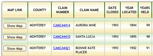
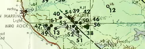
This report lists placer claims that were held more than 20 years that were located in areas that are now unclaimed. By reviewing this report, I found several claims in Monterey County California that looked interesting. Each placer claim was held continuously for almost 100 years, from the 1890s though the 1990s and is now on ground that is unclaimed.</p>
</div>
</td>	
<td>
<tdr>
        <div style="width:500px;" align="left"  "><img src="images/monterey.jpg" " width=506" height=187>
 		</div>
    </td>
<td> 
       	 <div style="width:560px; margin-right=10px" align="left" > 
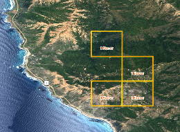
       	 <p>I used the show map link to find out basic information on the area where the old claims were located. This link takes you to an interactive Land Matters custom map of the area. On this map I found out that:</p>
<ul>
	<li>The area is part of the Los Padres National Forest</li>
	<li>There are current placer claims nearby indicating that the land is probably open to prospecting and entry.</li>
	<li>From the topo map, I located the names of some nearby historic mines. The Melville Mine and the Bucumo Mine. </li>
</ul>	
<p>With this information, I can now research the mining history of the area to determine if this would be a good place to take a look.</p>
</div>
</td>	
<hr>
  <td> 

       	 <div style="width:560px; margin-right=10px" align="left" > 
<p><strong>Using the  <a href="http://mylandmatters.org/Donate/Gift.html" target="_blank" > California Treasures Research DVD</a> </strong><br />
California Treasures is an exclusive Land Matters Research DVD that contains over 40,000 pages of searchable, historic mining reports and maps. Using the research dvd, I can search all documents at once for information on the area. I start with a search for the Melville Mine because it is within a mile of the area I am researching.  </p>
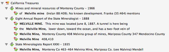
</p>The search returns 6 specific references to this mine. A review of the first of these references tells me that the area I am looking at is in the Los Burros Mining District, a gold and silver district only three miles from the Pacific Ocean. I have a full review of active mines from 1888 and a great summary of the mineral character of the area.
</p>
</div>
</td>	

<tdr>
        <div style="width:500px;" align="left"  "><img src="images/searchr.jpg" " width=560" height=175>
 		</div>
    </td>

<td> 
       	 <div style="width:560px; align="right"> 
<p><b>From the 8th Annual Report of the State Mineralogist of California (1888)</b><br /><em>"There are three characteristics that cannot escape the attention of an
observer in the Los Burros Mining District: Firstly, the placer gold is
mostly coarse gold, rough and angular, often adhering to fragments of
quartz. Therefore the gold cannot have traveled very far. It must have
come from the disintegration of rocks in the immediate vicinity.
Secondly, the numerous small irregular veins which traverse the various
formations, from the erosion of which much of the placer gold has probably
been derived. The gold in the bottom of the ravine is a concentration
from the whole mountain side, not necessarily coming from one original
source."</em>
</p>
</div>
</td>	

 <td> 

       	 <div style="width:560px; margin-right=10px" align="left" > 
<p>Browsing the Monterey County Report (1966) that is included on the DVD gives me an historic  Geologic Map and the names and locations of more Gold mines to research.</p>
</div>
</td>	

<tdr>
        <div style="width:500px;" align="right"  "><img src="images/montgeol.jpg" " width=493" height=168>
 		</div>
    </td>
<br />
<hr>
 <td> 

       	 <div style="width:560px; margin-right=10px" align="left" > 
<p>One thing leads to another and with these tools, you can head out to the Monterey County Goldfields with the advantage of knowing where to go, and what to look for. </p> 	
</div>
</td>	
<td> 
       	 <div style="width:560px; align="left"> 
<p>Get the <a href="http://mylandmatters.org/Donate/Membership/Claims_Advantage.html" target="_blank" >Land Matters Claims Advantage </a> and </p> <a href="http://mylandmatters.org/Donate/Gift.html" target="_blank" > California Treasures </a> today and find a new place to prospect tomorrow!</p>
</div>
</td>	
</tr>
</table>
]]></content>
		<id>http://mylandmatters.com/News/Items/index.php?entry=entry171127-175812</id>
		<issued>2017-11-27T00:00:00Z</issued>
		<modified>2017-11-27T00:00:00Z</modified>
	</entry>
	<entry>
		<title>Mine Showcase - Oroville Dredge Fields</title>
		<link rel="alternate" type="text/html" href="http://mylandmatters.com/News/Items/index.php?entry=entry170724-170811" />
		<content type="text/html" mode="escaped"><![CDATA[
<table border="0" width=“592">
      <tr valign="top" >
        <td> 
       	 <div style="width:312px; margin-right=10px" align="left" >  
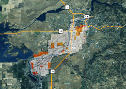
<strong>Oroville, CA - Historic Dredge Operation</strong>
<br />
<strong>Location:</strong> On the Feather River, Oroville, CA<br />
<strong>Size:</strong> 1-2 Miles wide, 9 miles long.<br />
<strong>Depth:</strong> 30 - 40 ft.<br />
<strong>First Bucket Line Dredge in California:</strong> 1898<br />
<strong>Status:</strong> Historic <br />
<strong>Production Total</strong> Estimated 1,964,000 oz  Gold <br />
<br />
<a href="http://www.mylandmatters.org/Maps/ShowMe/MapOrovilleDredge" target="_blank" >See our Custom Map.</a> 
<p>Use the Custom Map link above and see an interactive map of the historic dredge works. Look upstream to find the Oroville Dam.

<a href="http://mylandmatters.org/Images/dredgemap1.jpg" target="_blank" > CLICK HERE </a> to view the original, detailed map with a legend of dredge activities.</p>
</div>
		</td>
<td>
        <div style="width:260px;" align="left"  "><img src="images/dm2.jpg" " width=260" height=183>
 		</div>
    </td>
		</tr> 
</table>
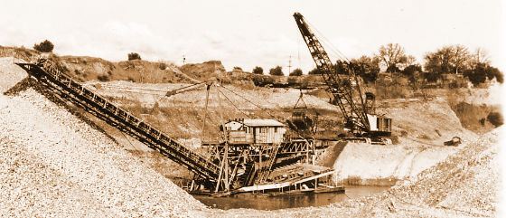
<p>Oroville, California became a topic of interest earlier this year when the Oroville Dam spillway was washed away. Just downriver from the dam is one of the largest historic gold dredging operations in the country. In 1908 there were 35 dredges operated simultaneously on the Feather River at Oroville. Dredging operations were active as late as 1952. </p>
<table>		
<tr valign="top" >
 <td> <div style="width:592px; margin-right=10px" align="left" >  
<p>Read all the details of all of the historic dredge operations in <strong>California Bulletin no 57</strong>. Gold Dredging in California. <a href="http://www.mylandmatters.org/Library/Item=146" target="_blank" >Download it from the Land Matters Library.</a> </p>
</div>
</td>
</table>
<br /><img src="images/Oroville_Dredge.jpg" " width=560" height=241><br />Dredge at Oroville]]></content>
		<id>http://mylandmatters.com/News/Items/index.php?entry=entry170724-170811</id>
		<issued>2017-07-24T00:00:00Z</issued>
		<modified>2017-07-24T00:00:00Z</modified>
	</entry>
	<entry>
		<title>National Park Maps &amp; Resources</title>
		<link rel="alternate" type="text/html" href="http://mylandmatters.com/News/Items/index.php?entry=entry170624-214434" />
		<content type="text/html" mode="escaped"><![CDATA[
<table border="0" width=“592">
		<tr valign="top" >
        <td>
        <div style="width:580px;" align="left" ><img src="images/harpers.png" " width=560" height=193>
</div>
                </td>
		</tr> 
      <tr valign="top" >
        <td> 
       	 <div style="width:592px; margin-right=10px" align="left" >  
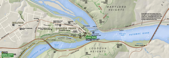
<p>When I was a child, we spent many summer weekends visiting National Battlefields. I learned the history of battles that had happened all around the places where we lived. I am still discovering new things about the places most familiar to me. As Land Matters grows, we hope to help you discover some of the interesting things in your own neighborhood. </p>
<p>
In the Land Matters library you can seek out your own park adventure. Find nearby National Parks and Park Units (including National Battlefields) for an interesting day trip. There are several ways to do this. You can search by park name, state or keyword to find what you are looking for. </p>
<div align="center"><b>Choose one of these TABS in the Land Matters Library:</b></div>
<p><b>Resources: </b>Get links to park websites for ALL the details. </p>
<p><b>Collections: </b>Search the Map Collection to Download a MAP of where you are going.</p>
<p><b>Quick Search:</b> Find documents on the geology, maps and other information about your favorite park simply by typing in the park name.</p>
</div></td></tr>
  </table>
<br /><a href="http://mylandmatters.org/Library/" target="_blank" >Go to the Land Matters Library</a> ]]></content>
		<id>http://mylandmatters.com/News/Items/index.php?entry=entry170624-214434</id>
		<issued>2017-06-25T00:00:00Z</issued>
		<modified>2017-06-25T00:00:00Z</modified>
	</entry>
	<entry>
		<title>Mine Showcase - Bingham Canyon, UT</title>
		<link rel="alternate" type="text/html" href="http://mylandmatters.com/News/Items/index.php?entry=entry170622-144923" />
		<content type="text/html" mode="escaped"><![CDATA[
<table border="0" width=“592">
      <tr valign="top" >
        <td> 
       	 <div style="width:312px; margin-right=10px" align="left" >  
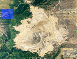
<strong>Bingham Canyon Mine - Rio Tinto Kennecott</strong>
<br /><br />
<strong>Location:</strong> 25 miles SW of Salt Lake City, Utah<br />
<strong>Depth:</strong> About 4,000 ft<br />
<strong>Width:</strong> 2.75 miles across<br />
<strong>Start of Production:</strong> 1906<br />
<strong>Status:</strong> Active<br /><br />

<strong>Annual Production</strong><br />
<strong>Copper(Cu)</strong> - 275,000 tons refined<br />
<strong>Gold (Au) </strong>- 400,000 oz<br />
<strong>Silver (Ag)</strong> - 4,000,000 oz<br />
<strong>Molybdenum (Mo)</strong> - 25,000,000 lbs<br />
</div>
		</td>
<td>
        <div style="width:260px;" align="center" ><img src="images/bingham1.jpg" " width=260" height=200>
 		</div>
    </td>
		</tr> 
</table>
<p>Bingham Canyon Mine is the second-largest copper production site in the United States and provides nearly 25% of the countrys copper. It is also the largest man-made excavation in the world and is considered to have produced more copper than any mine in history - more than 19 million tons.</p>
<table>		
<tr valign="top" >
 <td> 
       	 <div style="width:312px; margin-right=10px" align="left" >  
<a href="http://www.mylandmatters.org/Maps/ShowMe/MapBingham" target="_blank" >See our Custom Map of the mine.</a> 

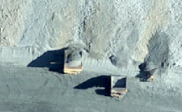
<p>Use the Show Map link above to wander around the mine with aerial imagery. I found the image at right of mine trucks in action on my own tour of the the great pit.
<a href="http://mylandmatters.org/Images/bingham_trucks.jpg" target="_blank" >Click</a>  for a larger image in context.</p>
<p>Bingham Canyon Mine has a vistors center for the public. However. it may still be closed due to the major mine landslide back in 2013. Check the <a href="http://www.kennecott.com/" target="_blank" >Kennecott</a> website for details. It’s certainly on my list wondrous places to visit.</p>
</div>
		</td>
        <td>
        <div style="width:260px;" align="center" ><img src="images/btrucksm.png" " width=260" height=160>
                </div>
                </td>
		</tr> 
  </table>
]]></content>
		<id>http://mylandmatters.com/News/Items/index.php?entry=entry170622-144923</id>
		<issued>2017-06-22T00:00:00Z</issued>
		<modified>2017-06-22T00:00:00Z</modified>
	</entry>
	<entry>
		<title>New Features</title>
		<link rel="alternate" type="text/html" href="http://mylandmatters.com/News/Items/index.php?entry=entry170622-133412" />
		<content type="text/html" mode="escaped"><![CDATA[You may have noticed that posts to our  <b>New &amp; Views</b> section have been light over the last few months.  The lack of content is due in part to the reduction in land actions being proposed since our new president took office. At the end of last year there were proposed withdrawals being published each week. Many of these are now under review by the new administration. We will keep you updated on any changes that occur. <br /><br />Only a few very small withdrawals have been recently proposed.  Because our time won't be spent mapping  land withdrawals, we will be able to add a few other features to  <b>New &amp; Views</b>  that I think you will enjoy. <br /><br />I recently had visitors from the East Coast who were fascinated by the sheer size of the active mines they saw on their explorations around Arizona (and that was what could be seen from the road!) Those unfamiliar with western lands are generally unexposed to the mining industry and have a limited understanding of the actual size of these mines and the importance of their production.<br /><br />I will be doing a series of posts on some of the more interesting mines in the United States with basic facts and a custom map to take you around the mine site. First up is Bingham Canyon in Utah. Wander around and take a look at one of the largest active mines in the country.]]></content>
		<id>http://mylandmatters.com/News/Items/index.php?entry=entry170622-133412</id>
		<issued>2017-06-22T00:00:00Z</issued>
		<modified>2017-06-22T00:00:00Z</modified>
	</entry>
	<entry>
		<title>AZ - Vulture Mountains Rec Area</title>
		<link rel="alternate" type="text/html" href="http://mylandmatters.com/News/Items/index.php?entry=entry161213-195758" />
		<content type="text/html" mode="escaped"><![CDATA[
<table border="0" width=“592">
      <tr valign="top" >
        <td> 
       	 <div style="width:312px; margin-right=10px" align="left" >  
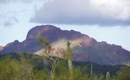
The BLM is proposing a lease of about 1,046 acres of public land in Maricopa County, Arizona. The area is split into two parcels. One that borders the famous Vulture Mine, and a second that covers a commonly used parking and camping area in the Vulture Mountains. 
<br /><br />
Maricopa County proposes to use the land for a variety of recreation facilities to be associated with the Vulture Mountains Cooperative Recreation Management Area. This is to be a cooperatively managed area between the BLM and Maricopa County. Related improvements for the proposed lease include picnic and camping facilities, restrooms, trailheads, developed day use facilities, and parking.<br /><br />
This is a highly mineralized area and has been prospected throughout the regions history. The land specified will be withdrawn from the General Mining Laws.
</div>
		</td>
        <td>
        <div style="width:260px;" align="center" ><img src="images/vulture.jpg" " width=260" height=160>
<br /><br />
<a href="https://www.federalregister.gov/documents/2016/11/08/2016-26942/notice-of-realty-action-classification-of-lands-for-recreation-and-public-purposes-act-lease-for-the" target="_blank" >Read the Details</a> 
<br /><br />
<a href="http://www.mylandmatters.org/Maps/ShowMe/MapAZ_WD_Vulture" target="_blank" >See our Map of the area.</a> 
                </div>
                </td>
		</tr> 
  </table>
]]></content>
		<id>http://mylandmatters.com/News/Items/index.php?entry=entry161213-195758</id>
		<issued>2016-12-14T00:00:00Z</issued>
		<modified>2016-12-14T00:00:00Z</modified>
	</entry>
	<entry>
		<title>ME - Katahdin Woods &amp; Waters National Monument</title>
		<link rel="alternate" type="text/html" href="http://mylandmatters.com/News/Items/index.php?entry=entry160927-212108" />
		<content type="text/html" mode="escaped"><![CDATA[
<table border="0" width=“592">
      <tr valign="top" >
        <td> 
       	 <div style="width:312px; margin-right=20px" align="left" >  
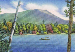
Our newest national monument, Katahdin Woods and Waters National Monument, located in central Maine, was established by <a href="https://www.federalregister.gov/documents/2016/08/29/2016-20786/establishment-of-the-katahdin-woods-and-waters-national-monument" target="_blank" >Presidential Proclamation 9476</a> under the authority of the Antiquities Act on August 24, 2016. <br/><br />
Approximately 87,500 acres of land was donated by Elliotsville Plantation Inc. and the Roxanne Quimby Foundation has established a "substantial" endowment with the National Park Foundation to support the administration of this national monument. It will be administered by the National Park Service.

		</div>
		</td>
        <td>
        <div style="width:260px;" align="right" ><img src="images/katahdin_blue.png" " width=260" height=180>
                </div>
                </td>
		</tr> 
  </table>
<br />Our Land Matters <a href="http://mylandmatters.org/Maps/ShowMe/MapME_katahdinNM" target="_blank" >Katahdin Map</a> shows the location and boundaries of this new monument. Check out the new <a href="https://www.nps.gov/kaww/index.htm" target="_blank" >NPS Website</a> for more monument details and recreation maps. This is the first in a series of posts about our newest National Monuments.  ]]></content>
		<id>http://mylandmatters.com/News/Items/index.php?entry=entry160927-212108</id>
		<issued>2016-09-28T00:00:00Z</issued>
		<modified>2016-09-28T00:00:00Z</modified>
	</entry>
	<entry>
		<title>Find a Meteorite in Your Own Backyard</title>
		<link rel="alternate" type="text/html" href="http://mylandmatters.com/News/Items/index.php?entry=entry160924-125556" />
		<content type="text/html" mode="escaped"><![CDATA[
<table border="0" width=“592">
      <tr valign="top" >
        <td> 
       	 <div style="width:312px; margin-right=20px" align="left" >  
Land Matters has a new Meteorite Map. <br/><br />
Our <a href="http://mylandmatters.org/Maps/Mineral.html" target="_blank" >United States Meterorite Falls</a> shows the locations of over 2,000 metorite falls in the US. <br /><br />
There is a wealth of information about each fall behind the map.
Use the <a href="http://mylandmatters.org/Maps/About/UsingMaps.html" target="_blank" >Map Information Tool</a> to link directly to the Meteoritical Bulletin Database details on any fall to get more specific information. You will find info on when the fall occurred, what type of meteorite it is, images of the meteorites themselves and everything else that is known about the fall.
		</div>
		</td>
        <td>
        <div style="width:260px;" align="right" ><img src="images/meteor1.png" " width=260" height=181>
                </div>
                </td>
		</tr> 
  </table>
<br />The Meteorite Bulletin Database is the offical database of the <a href="http://meteoriticalsociety.org" target="_blank" >Meteoritical Society</a>. This international organization names and records all meteorite falls and is the primary resource for meteoritic information.<br /><br /> <b>SELECT</b> the <i>United States Meteorite Falls</i> map  from the <a href="http://mylandmatters.org/Maps/Mineral.html" target="_blank" >Minerals Maps</a> right hand menu and find a meteorite of your own!    <br />	]]></content>
		<id>http://mylandmatters.com/News/Items/index.php?entry=entry160924-125556</id>
		<issued>2016-09-24T00:00:00Z</issued>
		<modified>2016-09-24T00:00:00Z</modified>
	</entry>
	<entry>
		<title>Find a Meteorite in Your Own Backyard</title>
		<link rel="alternate" type="text/html" href="http://mylandmatters.com/News/Items/index.php?entry=entry160924-125556" />
		<content type="text/html" mode="escaped"><![CDATA[
<table border="0" width=“592">
      <tr valign="top" >
        <td> 
       	 <div style="width:312px; margin-right=20px" align="left" >  
Land Matters has a new Meteorite Map. <br/><br />
Our <a href="http://mylandmatters.org/Maps/Mineral.html" target="_blank" >United States Meterorite Falls</a> shows the locations of over 2,000 metorite falls in the US. <br /><br />
There is a wealth of information about each fall behind the map.
Use the <a href="http://mylandmatters.org/Maps/About/UsingMaps.html" target="_blank" >Map Information Tool</a> to link directly to the Meteoritical Bulletin Database details on any fall to get more specific information. You will find info on when the fall occurred, what type of meteorite it is, images of the meteorites themselves and everything else that is known about the fall.
		</div>
		</td>
        <td>
        <div style="width:260px;" align="right" ><img src="images/meteor1.png" " width=260" height=181>
                </div>
                </td>
		</tr> 
  </table>
<br />The Meteorite Bulletin Database is the offical database of the <a href="http://meteoriticalsociety.org" target="_blank" >Meteoritical Society</a>. This international organization names and records all meteorite falls and is the primary resource for meteoritic information.<br /><br /> <b>SELECT</b> the <i>United States Meteorite Falls</i> map  from the <a href="http://mylandmatters.org/Maps/Mineral.html" target="_blank" >Minerals Maps</a> right hand menu and find a meteorite of your own!    <br />	]]></content>
		<id>http://mylandmatters.com/News/Items/index.php?entry=entry160924-125556</id>
		<issued>2016-09-24T00:00:00Z</issued>
		<modified>2016-09-24T00:00:00Z</modified>
	</entry>
	<entry>
		<title>BLM adjusts Mineral Management fees</title>
		<link rel="alternate" type="text/html" href="http://mylandmatters.com/News/Items/index.php?entry=entry160923-111403" />
		<content type="text/html" mode="escaped"><![CDATA[This final rule updates the fees set forth in the Bureau of Land Management (BLM) mineral resources regulations for the processing of certain minerals program-related actions. It also adjusts certain filing fees for minerals-related documents. These updated fees include those for actions such as lease renewals and mineral patent adjudications.<br /><br />Under this rule, 30 fees will remain the same and 18 fees will increase. Of the 18 fees that are being increased by this rule, 15 of the increases are equal to $5 each. The largest increase, $35, will be applied to the fee for adjudicating a mineral patent application containing more than 10 claims, which will increase from $3,075 to $3,110. The fee for adjudicating a patent application containing 10 or fewer claims will increase by $20, from $1,535 to $1,555. The “plus per acre nomination fee” for geothermal development will increase from $0.11 to $0.12.<br /><br /><a href="https://www.federalregister.gov/documents/2016/09/23/2016-22841/minerals-management-adjustment-of-cost-recovery-fees?" target="_blank" > Read the Federal Register Notice here.</a> ]]></content>
		<id>http://mylandmatters.com/News/Items/index.php?entry=entry160923-111403</id>
		<issued>2016-09-23T00:00:00Z</issued>
		<modified>2016-09-23T00:00:00Z</modified>
	</entry>
	<entry>
		<title>BLM adjusts Mineral Management fees</title>
		<link rel="alternate" type="text/html" href="http://mylandmatters.com/News/Items/index.php?entry=entry160923-111403" />
		<content type="text/html" mode="escaped"><![CDATA[This final rule updates the fees set forth in the Bureau of Land Management (BLM) mineral resources regulations for the processing of certain minerals program-related actions. It also adjusts certain filing fees for minerals-related documents. These updated fees include those for actions such as lease renewals and mineral patent adjudications.<br /><br />Under this rule, 30 fees will remain the same and 18 fees will increase. Of the 18 fees that are being increased by this rule, 15 of the increases are equal to $5 each. The largest increase, $35, will be applied to the fee for adjudicating a mineral patent application containing more than 10 claims, which will increase from $3,075 to $3,110. The fee for adjudicating a patent application containing 10 or fewer claims will increase by $20, from $1,535 to $1,555. The “plus per acre nomination fee” for geothermal development will increase from $0.11 to $0.12.<br /><br /><a href="https://www.federalregister.gov/documents/2016/09/23/2016-22841/minerals-management-adjustment-of-cost-recovery-fees?" target="_blank" > Read the Federal Register Notice here.</a> ]]></content>
		<id>http://mylandmatters.com/News/Items/index.php?entry=entry160923-111403</id>
		<issued>2016-09-23T00:00:00Z</issued>
		<modified>2016-09-23T00:00:00Z</modified>
	</entry>
</feed>
<!-- generation  time Page Generated in 0.0338 seconds - improved by SPB content cache  - http://joel.mine.nu/slog/static.php?page=simplephpblog_content_cache -->